
Editorial: Fending off flooding: Urging city to prioritize a renovation project on San Francisquito creek
Gavin Zhang
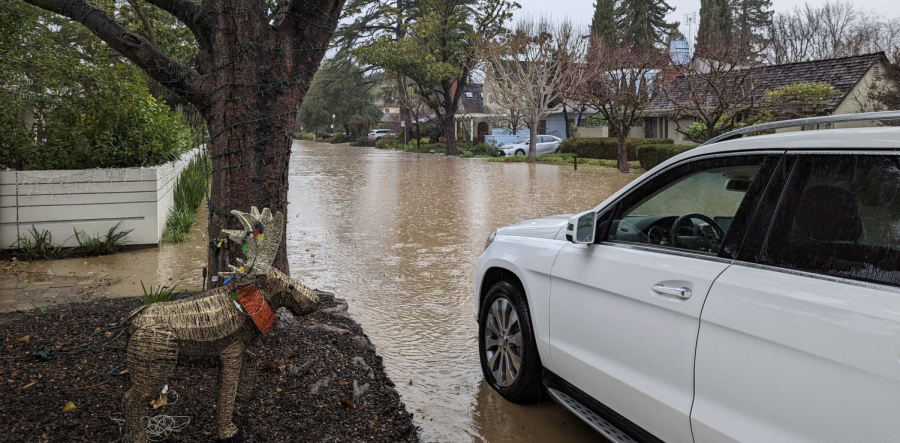
CREEK CATASTROPHE — Over winter break, the San Francisquito Creek overflowed into nearby neighborhoods. Freshman Gavin Zhang was one of many residents living near the site. “I heard that many houses near me had their garages or basements flooded,” Zhang said. “I think Palo Alto was just not prepared for that kind of storm.”
The Bay Area had a record-breaking rainy season this December and January, as, according to the National Weather Service, it was the rainiest 10-day period since 1862. Averaging over 10 inches of rain, compared to the last 5-year-average of 2.8 inches, as reported by Current Results, these storms were unexpected, leading to flooding in Palo Alto and detrimental effects state-wide.
As Palo Alto residents scrambled for sandbags to protect their homes, the question arose as to whether there was anything the city could have done to better prepare for this harsh weather aside from flood damage control.
There is currently an ongoing project that would help decrease flooding on the San Francisquito Creek. According to Claire Raybould, Palo Alto City senior planner on the San Francisquito Creek project, construction has been delayed due to lawsuits and California Environmental Quality Act approvals. We urge the city to prioritize the project and finish construction to avoid future floods.
Though the Bay Area faced less severe flooding than other coastal areas, the project would reduce flooding by improving flow into the bay. The creek lines the border between Palo Alto and Menlo Park and empties out into the San Francisco Bay, making it a crucial drainage system for local cities.
This project is overseen by the San Francisquito Creek Joint Powers Authority, in cooperation with the US Army Corporation of Engineering, and would widen some parts of the creek and replace the Pope Chaucer Street Bridge and the Newell Road Bridge.
“Pope-Chaucer Bridge is currently the biggest constraint in terms of allowing the flooding to pass,” Raybould said.
Construction on the Newell Road Bridge is expected to launch this year and finish in 2024, with construction on the Pope-Chaucer Bridge following shortly. Once this is complete, the creek will reach a standard known as the 70-year-flood — how often that storm would occur on average.
“A key goal of the project is to try and move forward with what we came up with for 70-year-flood improvements, and then with the idea that it doesn’t preclude future improvements that would allow for the 100 year storm to pass,” Raybould said.
While the project has a hefty $14.8 million cost, as stated by the US Army Corps of Engineers San Francisco District website, damages from the floods are much more costly compared to the project’s price. In just one year the cost to repair the winter season’s flooding has been as high as $28 million. According to an article from APNews, rainfall in California is only increasing, and could grow 34% by 2050 due to climate change. This further emphasizes the need for this project.
All things considered, the project would prevent future flooded houses and millions of dollars for city repairs. It must be prioritized to keep Palo Alto a well-constructed and safe town for all its residents.